The location of
the tropical depression at 19:00 on October 16 was about 15.2 degrees North
latitude; 109.2 degrees East longitude, right on the waters of the provinces
and cities from Da Nang to Binh Dinh.
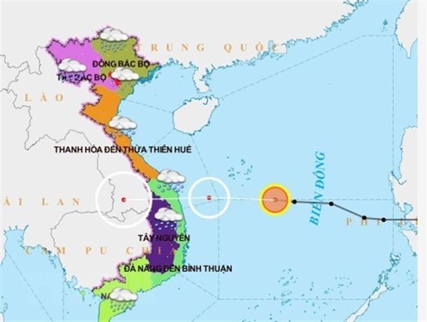
Forecast of tropical depression in the East Sea. (Source: VNA broadcast)
According to the National Center for Meteorological and Hydrological Forecasting, at 7 o'clock on October 16, the tropical low pressure center was at about 15.4 degrees North latitude; 112.3 degrees East longitude, right on the southern sea of Hoang Sa archipelago, about 360km east of the coast of provinces and cities from Da Nang to Binh Dinh.
The strongest wind in the area near the center of strong tropical depression is level 6 (40-50 km / h), level 8.
It is forecasted that, from 7 a.m. on October 16 to 19 p.m. on October 16, tropical depressions will move westward, from 25-30 kilometers per hour.
The position of the tropical low pressure at 19:00 on October 16 was about 15.2 degrees north latitude; 109.2 degrees East longitude, right on the waters of the provinces and cities from Da Nang to Binh Dinh. The strongest wind in the area near the center of strong tropical depression is level 6 (40-50 km / h), level 8.
It is forecasted that, from 19:00 on October 16 to 7 o'clock on October 17, the tropical depression moves in the West direction, every hour goes about 20km, goes inland in the Central Central provinces and then weakens gradually into a low pressure area in the southern part of Laos.
The danger zone caused by tropical depression in the South China Sea from 7 o'clock on October 16 to 7 o'clock on October 17 (strong winds of level 6 or higher, jerk from level 8 or higher) is from latitude 13.5 to 17, 0 North Latitude; west longitude 113.5 degree East longitude.
All vessels operating in the danger zone are at high risk of the impact of strong winds. The level of natural disaster risk is level 3.
At sea, due to the influence of tropical low pressure circulation combined with cold air, the southern part of the Paracel archipelago, the western sea area in the Middle East Sea has strong winds of level 6, level 8; rough seas.
From noon and the afternoon of October 16, the seas from the provinces and cities from Da Nang to Binh Dinh had strong winds of level 6, level 8; rough seas; sea waves from 2.0 to 4.0 m high.
The South China Sea region has strong southwest winds level 5, sometimes level 6, level 7-8, only the western sea area of the South China Sea (including the Spratly Islands waters) and the sea from Binh Thuan to Ca Mau level 6, level 8; sea waves 2.5-3.5m high, rough seas.
In addition, due to the influence of cold air, in the Gulf of Tonkin and the North East Sea (including the northern waters of the Paracel archipelago), there is strong Northeast wind level 6, level 8, from noon 16 / 10 increased to level 7, shock level 9; waves in the Gulf of Tonkin are 2.0-4.0m high; in the North East Sea 3.0-5.0m; strong seas.
Experts recommend fishermen and crew members: When operating ships, boats to avoid storms or tropical depressions at sea, they must always keep boats away from the center of storms, tropical depression at a minimum distance of 350 to 400km - about 200 nautical miles.
When it is impossible to stay away from the areas directly affected by storms or tropical depressions, but enter the stormy wind or tropical depression zone, the vehicle operator must be calm and focused on all abilities to bring ships and boats to quickly escape away from stormy and tropical low pressure areas.
From October 16-21, there is heavy rain in Central Vietnam, especially in Ha Tinh, Quang Binh, there is a chance of particularly heavy rain.
The total rainfall from October 16-21 in the provinces of Ha Tinh, Quang Binh is popular at 500-800mm, in some places over 900mm; In the provinces of Nghe An, Quang Tri, Thua Thien-Hue, it is popular at 300-500mm, in some places over 500mm; Popularity in provinces and cities from Da Nang, Quang Nam is 300-400mm, some places are over 500mm; from Quang Ngai to Phu Yen is popular at 200-300mm, in some places over 350mm.
From October 16 to October 18 in the Central Highlands, there was moderate rain, heavy rain, some places with very heavy rain with a total rainfall of 100-200 mm, some places over 250 mm.
After October 21, in the provinces of Central Central, South Central, there is a possibility of prolonged heavy rain. The level of natural disaster risk caused by heavy rain is level 2. /.