Trung tâm phòng tránh và giảm nhẹ thiên tai

Disaster Management Policyand Technology Center

Giao diện dễ tiếp cận vietnam english
Log in

Management - Cooperation - Work together

  • Homepage
  • About
    • About DMC
    • Organization Structure
    • Function & Tasks
    • Development stratery
  • News
    • National and International News
    • DMPTC News
  • Information Center
    • Disaster infomation
    • Basic knowledge
    • Library
      • Legal documents
      • Reference documents
      • IEC documents
      • CBDRM documents
        • Legal documents
        • Reference documents
        • IEC documents
    • CBDRM (Program 1002)
      • Project Matrix
      • Technical Assistance Network
      • CBDRM documents
        • Legal documents
        • Reference documents
        • IEC documents
      • Monitoring and Evaluation (M&E)
      • CBDRA
        • Disaster risks maps
        • CBDRA Reports
        • Other maps
      • Disaster prevention plans
    • Disaster risk maps
    • Irrigation systems
    • Trainings and Workshops
    • Gallery
  • Partners
  • Projects
  • DMC-Mail
  1. News
  2. Details
  • Share this on Facebook
  • Share this on Twitter
  • Share this on GooglePlus

Storm No.10 headed for Quang Ngai - Khanh Hoa

14:34:56, 11/11/2020
On November 5, typhoon Goni could land on the mainland of Quang Ngai - Khanh Hoa provinces with strong winds of level 8, shock level 10. Storm circulation caused rain in Central Vietnam.
At 7:00, the storm center was 400 km southeast of Hoang Sa archipelago and kept strong winds at level 8, level 10 during the past hours.

In the next 24 hours, the danger zone due to typhoon impacts in the East Sea lies from latitude 12.5 to 17 degrees north latitude and from longitude 111.5 to 118.5 east longitude. All vessels operating in the danger zone are at high risk of being affected by strong winds.

On the morning of November 3, typhoon number 10 (Goni) maintained the strongest wind at level 8, jerked to level 10. The storm has barely gotten stronger in the past 6 hours.

Day and night, the storm travels in the southwest direction with the speed of 10 km / h. On the morning of November 4, the storm center was about 290 km southeast of the Hoang Sa archipelago. The intensity tends to increase gradually to level 8-9, and level 11


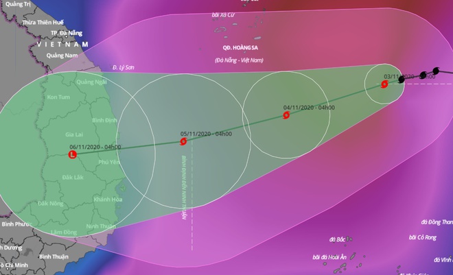
Typhoon Goni tends to move inland from Quang Ngai - Khanh Hoa provinces


This pattern maintains direction and speed for the following hours. At dawn of 5/11, the storm center was about 160 km east of Quang Ngai to Khanh Hoa. Strong wind strength reached level 9, shock level 11. The storm rose one level before entering the Central Coast.

On November 5, the storm entered the mainland provinces of Quang Ngai to Khanh Hoa and gradually weakened into a tropical depression and then turned into a low pressure area.

Thus, during the life cycle from now to landfall, the storm does not change direction and speed but moves mainly in the southwest direction, at 10 km / h.


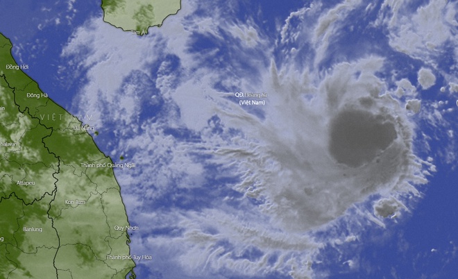
Satellite images of Typhoon Goni at dawn of 3/11 showed that this pattern began to re-establish the cloud structure and circulate after one day of dispersion


Về cường độ đổ bộ, cơ quan khí tượng Hong Kong và Nhật Bản cùng chung nhận định là ở thời điểm tiến vào vùng biển các tỉnh Trung Bộ, bão chỉ duy trì sức gió mạnh 65 km/h, tương đương cấp 8, giật cấp 10.

Quá trình đi vào đất liền, bão có dấu hiệu suy yếu thành áp thấp nhiệt đới và chỉ đạt cường độ 40 km/h, tương đương cấp 6 vào rạng sáng 6/11. Lúc này, tâm áp thấp nhiệt đới nằm ngay trên đất liền các tỉnh Quảng Ngãi - Khánh Hòa.

Kịch bản bão suy yếu trước khi đổ bộ đất liền có thể xảy ra. Dù vậy, hoàn lưu bão vẫn bao trùm các tỉnh từ Đà Nẵng đến Bình Thuận, gây ra một đợt mưa cho khu vực bắt đầu từ tối 4/11.

Cụ thể, mưa lớn tiếp diễn tại Trung Bộ trong ngày 4-7/11. Các tỉnh từ Thừa Thiên - Huế đến Quảng Ngãi có thể hứng chịu lượng mưa phổ biến 300-400 mm/đợt.

Trong khi đó, khu vực Bình Định, Phú Yên và bắc Tây Nguyên có mưa nhỏ hơn, khoảng 100-200 mm. Ảnh hưởng của đợt mưa này, lũ trên các sông, đặc biệt là Quảng Nam và Quảng Ngãi khả năng lên báo động 2, báo động 3 trong những ngày tới.


(Source: Zingnews.vn)

Read more

  • Yen Bai: Trees fell, houses had their roofs blown off, one person was injured due to a tornado
  • Dak Nong: Heavy rain accompanied by strong winds, greeting gates, trees in Gia Nghia city fell and fell
  • Malaysia records flood damage of over $210 million in 2024
  • Thanh Hoa: Escaped death when dozens of tons of rock fell on house
  • Ben Tre proactively responds to drought and salinity
  • The people of Lai Chau actively protect their livestock during the prolonged cold and severe cold weather.
  • Storm Tra Mi causes walls to collapse and roofs to be blown off in Quang Tri
  • Early resettlement for people living under landslides in Muong Nhe
  • Together, overcome difficulties, stabilize life
  • Nam Dinh evacuated nearly 500 households to safety due to the risk of rising flood waters.


  • Vietnam Natural Disaster Monitoring System (VNDMS)

  • Community-Based Disaster Risk Management Database (Project 553)

  • Socio-economic database

  • Riverbank landslides, coastal erosion database

  • Spatial for disaster management database

  • Library Disaster Management Policy and and Technology Center

  • Damage database

  • Satellite database

  • Science and Technology Database

  • Online Knowledge Dissemination Software for Disaster Prevention

  • Digital transformation portal in disaster management

  • Camera Management and Monitoring Software

Weather forecast

Copyright © 2015 - Disaster Management Policy and Technology Center

Address: No.54 - 102 Truong Chinh street, Dong Da, Ha Noi

Phone: +84-436291511 - Fax: +84-437336647

Email: trungtamcsktpctt@gmail.com - Website: www.dmptc.gov.vn

Online users: 397

Visistors: 19911474