Trung tâm phòng tránh và giảm nhẹ thiên tai

Disaster Management Policyand Technology Center

Giao diện dễ tiếp cận vietnam english
Log in

Management - Cooperation - Work together

  • Homepage
  • About
    • About DMC
    • Organization Structure
    • Function & Tasks
    • Development stratery
  • News
    • National and International News
    • DMPTC News
  • Information Center
    • Disaster infomation
    • Basic knowledge
    • Library
      • Legal documents
      • Reference documents
      • IEC documents
      • CBDRM documents
        • Legal documents
        • Reference documents
        • IEC documents
    • CBDRM (Program 1002)
      • Project Matrix
      • Technical Assistance Network
      • CBDRM documents
        • Legal documents
        • Reference documents
        • IEC documents
      • Monitoring and Evaluation (M&E)
      • CBDRA
        • Disaster risks maps
        • CBDRA Reports
        • Other maps
      • Disaster prevention plans
    • Disaster risk maps
    • Irrigation systems
    • Trainings and Workshops
    • Gallery
  • Partners
  • Projects
  • DMC-Mail
  1. News
  2. Details
  • Share this on Facebook
  • Share this on Twitter
  • Share this on GooglePlus

Saline intrusion in the No. 1 rice bowl in Vietnam: Decreases at the beginning of the week, increases at the weekend

10:48:27, 15/05/2020 Meteorological agency forecasts, from 11-20 / 5, the probability of the Mekong Delta region with scattered thunderstorms, saline intrusion decreases but is still high.


Forecast map of saline intrusion in Mekong Delta region.

According to the National Center of Hydrometeorological Forecasting, from today, 11/5 to 20/5, saline intrusion in the No. 1 rice bowl in Vietnam (Mekong Delta) tends to decrease gradually at the beginning of the week, then increase slightly at the end of the week. During this period, the Southern region is likely to have scattered thunderstorms in the evening, while thunderstorms and strong winds may occur. However, the rain is unevenly distributed and takes place in a short time with the total rainfall ranging from 20-50mm, some places are higher. The highest temperature in the South in the next 10 days is commonly in the range of 34-37 degrees Celsius.

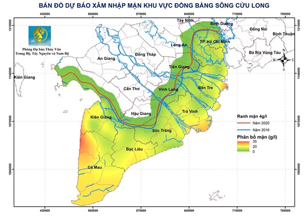
Regarding hydrological developments, the water level of stations on the Mekong mainstream in the coming days varies slowly, at the same level and higher than the average of many years from 0.1-0.3m. The water level on Tien and Hau rivers rises in the last days. In particular, the highest water level in Tan Chau is 1.25m; in Chau Doc 1.40m, higher than the average of the same period of the year from 0.25-0.4m. The salinity depth of 1g / l in this period in Vam Co Dong and Vam Co Tay rivers has 90-130km saline intrusion range; Cua Tieu and Cua Dai rivers of 55-70km; Ham Luong river 65-80km; Hau and Co Chien rivers 45-50km; Cai Lon river 52-58km. Similarly, the salinity depth of 4g / l during this period in Vam Co Dong and Vam Co Tay rivers has a saline intrusion range of 80-120km; Cua Tieu and Cua Dai rivers of 50-55km; Co Chien and Hau rivers 35-42km; Cai Lon river 45-52km ... The level of disaster risk from saline intrusion in the Mekong Delta during this period is at level 1-2. With the above developments, the meteorological agency forecasts that saline intrusion in the Mekong Delta is tending to decrease but still remains high. Therefore, localities before taking fresh water, watering crops and fruit trees need to closely monitor salinity levels.

(Source: Vietnam News Agency)

Read more

  • Yen Bai: Trees fell, houses had their roofs blown off, one person was injured due to a tornado
  • Dak Nong: Heavy rain accompanied by strong winds, greeting gates, trees in Gia Nghia city fell and fell
  • Malaysia records flood damage of over $210 million in 2024
  • Thanh Hoa: Escaped death when dozens of tons of rock fell on house
  • Ben Tre proactively responds to drought and salinity
  • The people of Lai Chau actively protect their livestock during the prolonged cold and severe cold weather.
  • Storm Tra Mi causes walls to collapse and roofs to be blown off in Quang Tri
  • Early resettlement for people living under landslides in Muong Nhe
  • Together, overcome difficulties, stabilize life
  • Nam Dinh evacuated nearly 500 households to safety due to the risk of rising flood waters.


  • Vietnam Natural Disaster Monitoring System (VNDMS)

  • Community-Based Disaster Risk Management Database (Project 553)

  • Socio-economic database

  • Riverbank landslides, coastal erosion database

  • Spatial for disaster management database

  • Library Disaster Management Policy and and Technology Center

  • Damage database

  • Satellite database

  • Science and Technology Database

  • Online Knowledge Dissemination Software for Disaster Prevention

  • Digital transformation portal in disaster management

  • Camera Management and Monitoring Software

Weather forecast

Copyright © 2015 - Disaster Management Policy and Technology Center

Address: No.54 - 102 Truong Chinh street, Dong Da, Ha Noi

Phone: +84-436291511 - Fax: +84-437336647

Email: trungtamcsktpctt@gmail.com - Website: www.dmptc.gov.vn

Online users: 221

Visistors: 19911474