Accordingly, the emergency situation of dangerous riverbank erosion in Ke Sach district, specifically at the bank of Rach Phung An river from An My Commune People's Committee to Cau Sap (including a landslide more than 200m long in front of the Commune People's Committee) An My); in dunes on Hau river, such as My Phuoc dune area (Nhon My commune); An Tan dunes, An Cong (An Lac Tay commune).
The People's Committee of Soc Trang province requested the Department of Agriculture and Rural Development (MARD) to regularly update and report on the situation of landslides and urgently overcome landslides to monitor and direct the handling in a timely manner. .
In addition, the People's Committee of Ke Sach district is responsible for presiding over and coordinating with the Department of Agriculture and Rural Development, the Department of Natural Resources and Environment (NRE) in deploying warning signs and zoning dangerous riverbank erosion. Propagating and disseminating riverbank erosion, dangerous landslide areas and areas at risk of landslides; mobilize people to move to other places... Overcome and minimize property damage, ensure the safety of people's lives, prepare plans to be ready to mobilize forces and supplies, means to assist people in relocation and rescue when bad situations happen…
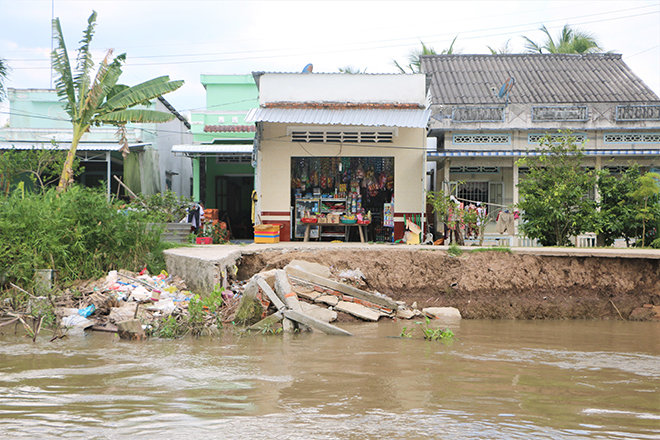
Landslides in Ke Sach district (Soc Trang).
Before that, at the end of April, in Ke Sach district, there was a river bank landslide in Phung An hamlet (An My commune). The landslide section is over 40m in length, about 10m deep inland, directly affecting the river dike section combined with rural roads.
Mr. Le Hoang Phong, Standing Vice Chairman of the People's Committee of Ke Sach District, said that the situation of landslides on riverbanks, canals, roads and houses in the district is happening more and more, especially when there are strong impacts. of storms, floods and high tides. Landslides damage infrastructure works, areas of houses on stilts along river banks, loss of land, affecting people's lives.
It is known that from 2015 up to now, on average, Ke Sach district has a landslide each year with a length of 2km, deeply eroded into concrete roads and orchards from 3-10m, the land area is about 1 ha/year. Particularly since the beginning of the year, there have been 13 sections of embankment erosion and rural roads, total length of 525m; 15 sections of dune dike erosion, total length 714m, total damage estimated at over 7 billion VND.
According to Director of Soc Trang Department of Agriculture and Rural Development, Huynh Ngoc Nha, climate change is becoming more and more severe, so landslides will continue to happen in riverside and coastal localities, especially in the months rainy season. Therefore, in the immediate future, localities should use the local funds for natural disaster prevention and control to overcome small landslide spots to ensure the travel and production of people. Particularly for large landslide spots that need support from the province, the agricultural sector will develop a plan as well as coordinate with the People's Committees of the districts to advise the Provincial People's Committee to implement plans to overcome landslides in the shortest time.
In An Giang, the People's Committee of this province has agreed on a plan to overcome landslides at Km22, provincial road 946 (Cho Moi district), allowing the Department of Transport (Transport) of the province to immediately implement the landslide remedy according to regulations. about emergency works. The solution to overcome landslides is to reinforce, arrange gabions, drop sand sacks to fill the vortex pits and 30cm thick rock mats. It is expected that the total cost of remediation will be about VND 3 billion, from the province's contingency and disaster recovery funds.
The People's Committee of An Giang province assigned the Department of Transport, Department of Agriculture and Rural Development, Steering Committee to respond to climate change - Disaster prevention and search and rescue of the province to urgently advise the Provincial People's Committee to decide to declare an emergency situation according to regulations. Before that, at 7:00 am on May 20, in Long Hoa hamlet, Long Dien B commune (Cho Moi district) a landslide occurred on the road surface of province 946. The road surface has dropped into the canal more than 4m deep into the road surface (more than 1/ 2 road surfaces) with a length of more than 40m and the risk of spreading affecting traffic safety.
The Commanding Committee for Disaster Prevention - Search and Rescue of Phong Dien District (Can Tho City) said that on May 22, in Nhon Ai commune, a river bank landslide caused many people's properties and houses to be damaged. collapsed into the river. The landslide occurred along the bank of Phong Dien river, in Nhon Phu hamlet, Nhon Ai commune with a length of over 50m, collapsing into the river the rear houses, fences, prefabricated houses ... of many households in the area.
According to local people, when they were living in the house, they heard the crackling sound from the back house and the fence, so they quickly escaped. Immediately after, the house behind, the prefabricated house, the stilt house and the fence... fell into the river. The landslide did not cause any loss of life, but property damage was over 220 million VND.
After the landslide occurred, leaders of Phong Dien district mobilized police forces, militia and self-defense forces ... to help people move assets out of the landslide area, the area with signs of cracks. Phong Dien District People's Committee requested the Department of Agriculture and Rural Development to coordinate with relevant sectors and local authorities to survey and implement measures to overcome landslides and ensure safety for people. Urgently advise the District People's Committee to support the costs of landslide-affected households to overcome the consequences according to regulations...