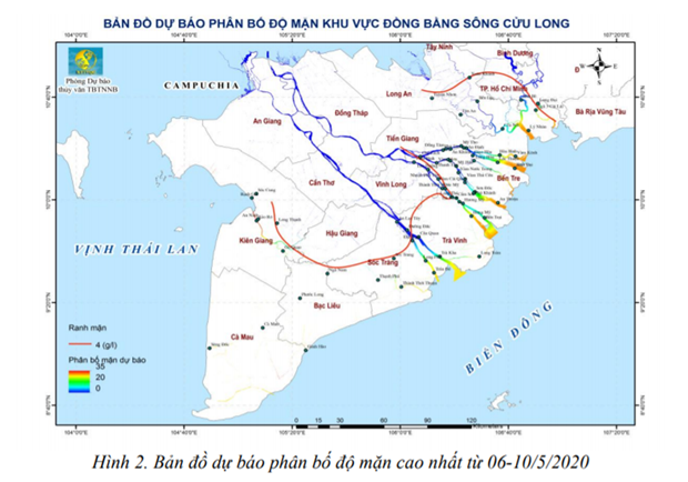
Map of the highest salinity distribution forecast from May 6-10, 2020.
According to hydro-meteorological agencies, from 6-10 / 5, saline intrusion in the Mekong Delta region tends to increase and reach the highest level at the weekend. The level of disaster risk due to saline intrusion is in level 1-2.
Therefore, in the next saline wave, from 8-15 / 5, localities restricted irrigation (minimum irrigation) to minimize production losses, for fruit trees with high economic value. High, poor salinity tolerance, before watering should check salinity concentration.
There is a chance of thunderstorms but the salinity is still high
Representatives of the National Center for Hydrometeorological Forecasting said saline intrusion in the Mekong Delta from May 1-5, tends to decrease. Particularly for some stations in Soc Trang, Ben Tre and Ca Mau, the salinity level is higher than the week from April 26-30.
In the coming days, from May 6-10, the Mekong Delta area is likely to have thunderstorms scattered in the evening in a short time. During a thunderstorm there is a possibility of tornadoes, lightning and strong winds.
However, the rain is not evenly distributed, the total rainfall is from 20-40mm, in some places it is over 70mm. The highest common temperature ranges from 33-37 degrees Celsius, the latter tends to decrease.
The water level of the stations on the Mekong mainstream changes slowly and is at a level of 0.2-1m higher than the average of many years.
Accordingly, the water level on the Tien and Hau rivers will rise with the tide. The highest water level of the week in Tan Chau is 1.30m; at Chau Doc, 1.45m, higher than the same period in 2016 by 0.15-0.2m.
Saline intrusion in Vietnam's No. 1 granary region tends to increase gradually and reaches the highest level at the end of the week. The highest salinity in this phase at the stations was equal and higher than the period from April 21-30; Particularly in Ca Mau, salinity is lower. The depth of salinity boundary is 1g / l during this period in Vam Co Dong and Vam Co Tay rivers with salinity intrusion range of 90-135km; Cua Tieu and Cua Dai rivers are 55-70km; Ham Luong river 65-85km; Hau and Co Chien rivers 45-50km; Cai Lon river 55-60km.
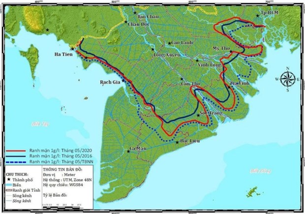
Salinity intrusion forecast (salinity boundary 4g / l) in May 2020. (Source: Vptt Vietnam Mekong River Commission)
Similarly, the saline depth of 4g / l during this period in Vam Co Dong and Vam Co Tay rivers has the saline intrusion range of 80-125km; saline intrusion range in Cua Tieu and Cua Dai rivers is 50-55km; Ham Luong river 60-75km; Co Chien and Hau rivers 35-40km; Cai Lon river 45-55km.
The total expected flow is about 84%.
In related, the Standing Office of the Mekong River Commission of Vietnam said that based on the rainfall forecast results in the Mekong basin, combined with the situation of water use and forecasting the tidal regime, the total flow to the Mekong Delta through the two stations of Tan Chau and Chau Doc is expected to reach about 84% of the average for many years and approximately the total flow of May 2016.
Based on the forecast of the flow to the Mekong Delta and the forecast of the tide in May, saline intrusion in May 2020 though tended to decrease slightly but remained at a high level.
Accordingly, the last 4g / l salinity line on the three major tributaries is the Hau River (on the Co Chien branch), Tien River (Ham Luong branch), and Vam Co Tay River expected to be deeper than the average for many years from 15-19km and 3-9km deeper than the saline intrusion in the same month of 2016.
Similarly, the 1 g / l salinity line on the three tributaries is expected to be 20 to 23 km deeper than the average of many years and about 8 km deeper than in May 2016.
According to the Standing Office of the Mekong River Commission of Vietnam, based on the results of forecasting the level of saline intrusion on the main tributaries, the number of hours that can open fresh water gates (salinity is less than 1g / l) in a month Year in some focal works will be markedly improved compared to April 2020.
Particularly, Rach Tranh and Bac Dong sluices on the Vam Co river system have not been able to collect water.