Trung tâm phòng tránh và giảm nhẹ thiên tai

Disaster Management Policyand Technology Center

Giao diện dễ tiếp cận vietnam english
Log in

Management - Cooperation - Work together

  • Homepage
  • About
    • About DMC
    • Organization Structure
    • Function & Tasks
    • Development stratery
  • News
    • National and International News
    • DMPTC News
  • Information Center
    • Disaster infomation
    • Basic knowledge
    • Library
      • Legal documents
      • Reference documents
      • IEC documents
      • CBDRM documents
        • Legal documents
        • Reference documents
        • IEC documents
    • CBDRM (Program 1002)
      • Project Matrix
      • Technical Assistance Network
      • CBDRM documents
        • Legal documents
        • Reference documents
        • IEC documents
      • Monitoring and Evaluation (M&E)
      • CBDRA
        • Disaster risks maps
        • CBDRA Reports
        • Other maps
      • Disaster prevention plans
    • Disaster risk maps
    • Irrigation systems
    • Trainings and Workshops
    • Gallery
  • Partners
  • Projects
  • DMC-Mail
  1. News
  2. Details
  • Share this on Facebook
  • Share this on Twitter
  • Share this on GooglePlus

Heavy rain causes landslides, Quang Nam evacuates 5,000 households

11:0:45, 31/12/2021 Many roads in Nam Tra My district were heavily flooded, separating communes from the center

At noon on November 29, Mr. Tran Duy Dung, Chairman of the People's Committee of Nam Tra My district, Quang Nam, said that the locality planned to evacuate 5,000 households in the affected area and at risk of landslides.

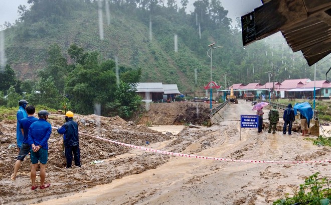
“For the past two days, continuous heavy rain has caused many roads in Nam Tra My district to be divided. In which, the road to Tra Linh commune was eroded at many points, completely divided; The road DH8 to Tra Leng commune was also damaged by the abutment of the bridge, the functional forces stretched the ropes to prevent people from going back and forth. The locality is evacuating about 5,000 households in the affected area," Dung said.


Nam Tra My district evacuated 5,000 households to ensure safety from heavy rain

On the morning of November 29, National Highway 40B, the section through the Oa River area (Tra Tan commune, Bac Tra My district) was heavily flooded; In addition, the section through Tra Giac commune (Bac Tra My district) and the section from Tra Son commune to Tra Mai (Nam Tra My district) suffered serious landslides, traffic to the center of Nam Tra My district was affected. Divided.

The Commanding Committee for Natural Disaster Prevention and Control and Search and Rescue of Quang Nam Province said that from 1:00 a.m. on November 28 to 1:00 a.m. on November 29, localities in the province experienced moderate, heavy rain, with very heavy rain in some places. rain in northern localities is common 20-50 mm; south common 70-120 mm. There are places with higher rainfall such as Tra My (Bac Tra My district) 158 mm, Xuan Binh (Nui Thanh district) 285 mm.

According to Quang Nam Hydro-Meteorological Station, from 1 a.m. on November 29 to 1 a.m. on December 1, localities in the province have moderate rain, heavy rain, and heavy rain in some places, then the rain tends to decrease.


Read more

  • Yen Bai: Trees fell, houses had their roofs blown off, one person was injured due to a tornado
  • Dak Nong: Heavy rain accompanied by strong winds, greeting gates, trees in Gia Nghia city fell and fell
  • Malaysia records flood damage of over $210 million in 2024
  • Thanh Hoa: Escaped death when dozens of tons of rock fell on house
  • Ben Tre proactively responds to drought and salinity
  • The people of Lai Chau actively protect their livestock during the prolonged cold and severe cold weather.
  • Storm Tra Mi causes walls to collapse and roofs to be blown off in Quang Tri
  • Early resettlement for people living under landslides in Muong Nhe
  • Together, overcome difficulties, stabilize life
  • Nam Dinh evacuated nearly 500 households to safety due to the risk of rising flood waters.


  • Vietnam Natural Disaster Monitoring System (VNDMS)

  • Community-Based Disaster Risk Management Database (Project 553)

  • Socio-economic database

  • Riverbank landslides, coastal erosion database

  • Spatial for disaster management database

  • Library Disaster Management Policy and and Technology Center

  • Damage database

  • Satellite database

  • Science and Technology Database

  • Online Knowledge Dissemination Software for Disaster Prevention

  • Digital transformation portal in disaster management

  • Camera Management and Monitoring Software

Weather forecast

Copyright © 2015 - Disaster Management Policy and Technology Center

Address: No.54 - 102 Truong Chinh street, Dong Da, Ha Noi

Phone: +84-436291511 - Fax: +84-437336647

Email: trungtamcsktpctt@gmail.com - Website: www.dmptc.gov.vn

Online users: 312

Visistors: 19911474