Trung tâm phòng tránh và giảm nhẹ thiên tai

Disaster Management Policyand Technology Center

Giao diện dễ tiếp cận vietnam english
Log in

Management - Cooperation - Work together

  • Homepage
  • About
    • About DMC
    • Organization Structure
    • Function & Tasks
    • Development stratery
  • News
    • National and International News
    • DMPTC News
  • Information Center
    • Disaster infomation
    • Basic knowledge
    • Library
      • Legal documents
      • Reference documents
      • IEC documents
      • CBDRM documents
        • Legal documents
        • Reference documents
        • IEC documents
    • CBDRM (Program 1002)
      • Project Matrix
      • Technical Assistance Network
      • CBDRM documents
        • Legal documents
        • Reference documents
        • IEC documents
      • Monitoring and Evaluation (M&E)
      • CBDRA
        • Disaster risks maps
        • CBDRA Reports
        • Other maps
      • Disaster prevention plans
    • Disaster risk maps
    • Irrigation systems
    • Trainings and Workshops
    • Gallery
  • Partners
  • Projects
  • DMC-Mail
  1. News
  2. Details
  • Share this on Facebook
  • Share this on Twitter
  • Share this on GooglePlus

Hau Giang continues to respond to the flood situation

16:15:58, 16/11/2022 On October 27, the Hau Giang Hydrometeorological Station continued to warn of high tides combined with high water levels on the Hau River and on-site rain causing flooding in the province.


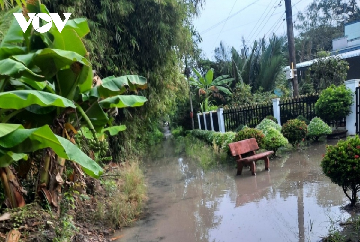
In recent days, heavy rain combined with high tide caused the water level to rise, causing flooding in many places in Hau Giang province.

In addition, the weather in Hau Giang province from October 28 to 30 in the morning, afternoon and night will have thunderstorms on a large scale, locally with heavy to very heavy rain in a short time, in a storm. thunderstorms accompanied by gusts of level 5 - 6 and thunder and lightning.


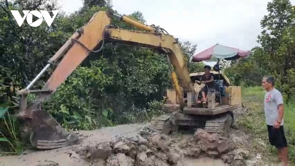
Farmers reinforce the embankment.

In the face of heavy rains combined with high tides causing water levels to rise, causing flooding in many places, the Standing Office of the Steering Committee for Disaster Prevention and Search and Rescue of Hau Giang province recommends that people in the province actively cover, enclose the banks of fish ponds, embankment of orchards, arrange pumps to pump water out. The roads are flooded, the water is fast, there are signs and pay attention to bring children to school during high tide, prohibiting children and students from bathing in the river. Horizontal boats, vertical boats, boats and boats operating on the river run slowly to limit surface waves, limit the risk of bank erosion and avoid eddy currents.
In the first days of November, the water level in the field in Hau Giang province is still high and the water recedes slowly, so localities should note to arrange the planting schedule for the winter-spring crop accordingly.


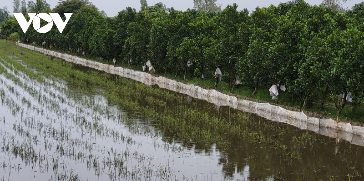
Implement many other measures to protect orchards.

Mr. Tran Thanh Toan - Chief of Standing Office of the Steering Committee for Disaster Prevention and Search and Rescue of Hau Giang province, said: "In the past few days, Hau Giang has affected the East Sea tide, causing flooding of the dyke. Through the survey, which affects the people's daily life as well as production, it is forecast that the water level is still high, the Provincial Steering Committee for Natural Disaster Prevention and Control and Search and Rescue directs the localities and the District Command. directing the specialized department to propagate for people to strengthen the dike sections, prepare pumps to be ready to pump water when the influence of tides causes flooding in their gardens, affecting production".


Read more

  • Yen Bai: Trees fell, houses had their roofs blown off, one person was injured due to a tornado
  • Dak Nong: Heavy rain accompanied by strong winds, greeting gates, trees in Gia Nghia city fell and fell
  • Malaysia records flood damage of over $210 million in 2024
  • Thanh Hoa: Escaped death when dozens of tons of rock fell on house
  • Ben Tre proactively responds to drought and salinity
  • The people of Lai Chau actively protect their livestock during the prolonged cold and severe cold weather.
  • Storm Tra Mi causes walls to collapse and roofs to be blown off in Quang Tri
  • Early resettlement for people living under landslides in Muong Nhe
  • Together, overcome difficulties, stabilize life
  • Nam Dinh evacuated nearly 500 households to safety due to the risk of rising flood waters.


  • Vietnam Natural Disaster Monitoring System (VNDMS)

  • Community-Based Disaster Risk Management Database (Project 553)

  • Socio-economic database

  • Riverbank landslides, coastal erosion database

  • Spatial for disaster management database

  • Library Disaster Management Policy and and Technology Center

  • Damage database

  • Satellite database

  • Science and Technology Database

  • Online Knowledge Dissemination Software for Disaster Prevention

  • Digital transformation portal in disaster management

  • Camera Management and Monitoring Software

Weather forecast

Copyright © 2015 - Disaster Management Policy and Technology Center

Address: No.54 - 102 Truong Chinh street, Dong Da, Ha Noi

Phone: +84-436291511 - Fax: +84-437336647

Email: trungtamcsktpctt@gmail.com - Website: www.dmptc.gov.vn

Online users: 353

Visistors: 19911474